Weather forecasting website Severe Weather Europe warns that the Arctic polar vortex could undergo a sudden stratospheric warming in early November, potentially the earliest on record. The rapid warming could weaken, displace, or split the vortex, then send Arctic air into the northern US and parts of Europe in the following weeks.
"The Polar Vortex is heading toward a record early disruption," Severe Weather Europe wrote in a report on Wednesday.
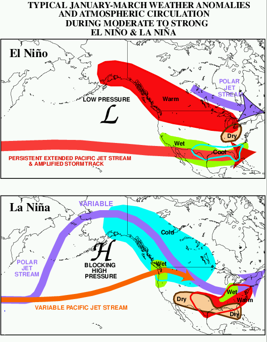
Severe Weather Europe continued, "An event this early is uncharted territory. With a Super El Niño already shaping the weather pattern, the impacts are harder to track than in mid-winter. But forecasts already show the first indirect links to the split cores, with cooler trends developing over parts of Europe and the eastern United States in coming weeks."
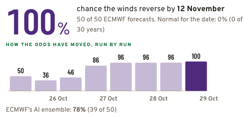
Arctic data dashboard Polar Vortex shows that all 50 members of the ECMWF ensemble forecast project a reversal of winds around the Arctic polar vortex by Nov. 12, pointing to a potentially unprecedented early-season disruption.
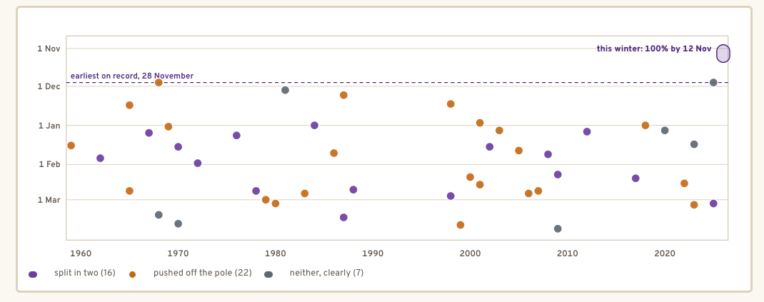
The shift from westerly to easterly winds did not occur by that date in any year during the 1991 to 2020 comparison period. The dashboard cites data showing that the earliest major sudden stratospheric warming in records dating to 1959 occurred on Nov. 28, in both 1968 and 2025.
What the report says:
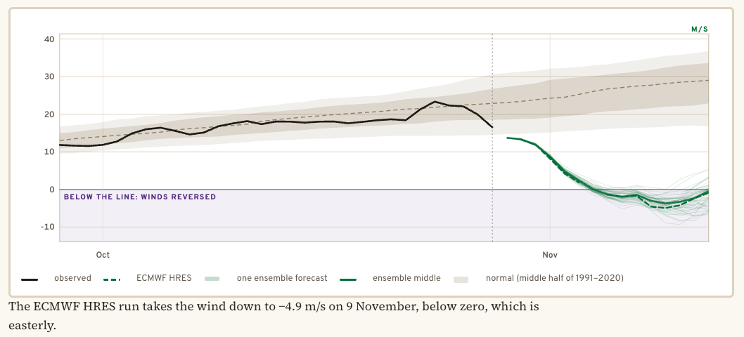
The forecast in one picture
The thick line is the wind around the Arctic vortex, measured each day. Each thin line is one of the 50 ECMWF ensemble forecasts; the solid line through them is their middle, and the dashed line is ECMWF's main forecast. The shaded band is normal for the time of year. Below zero, the winds have reversed.
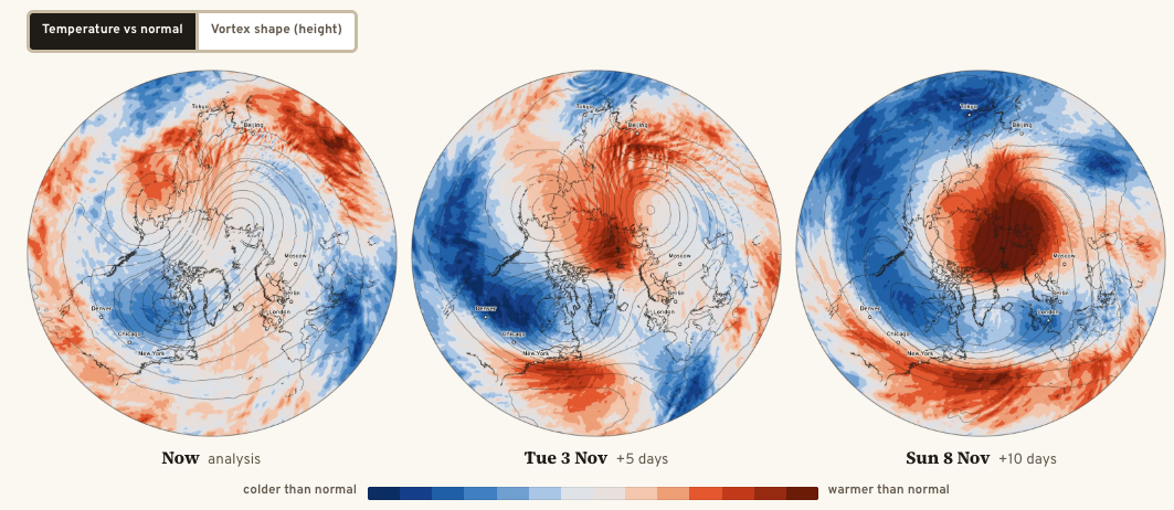
Watch it on the map
Thirty kilometers up, over the Arctic, red is warmer than normal for the date, and blue is colder. The dark lines trace the vortex. In a sudden warming, a red patch spreads over the pole and the lines pull apart.
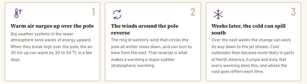
What happens when the vortex breaks
Every sudden warming since 1959
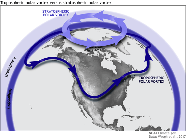
Below is an example from NOAA showing how a disrupted polar vortex releases cold polar air into the US or Europe in winter.
Meteorologist Ryan Kane wrote on X:
However, given the typical 2–4-week lag associated with SSW events, some type of pattern change by mid-to-late November remains possible as the SSW event couples down to the troposphere, weakening the tropospheric polar vortex, potentially displacing the cold.
For now, my focus remains on the next two weeks, which look warm and generally above average, with no significant Arctic air intrusions expected east of the Rockies as pacific air continues to pour in.
I'll continue monitoring the mid-to-late November period as it comes into better forecast range and we see how guidance handles the potential impacts of the SSW event
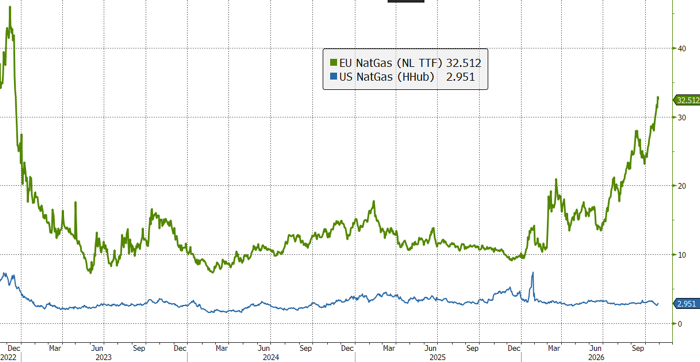
As meteorologists monitor whether the potential stratospheric warming event could trigger Arctic air outbreaks across the US or Europe, natural gas markets reveal a stark price divide.
European natural gas trades at roughly 11 times the US price.